Mile 289 Report
Kincheloe Point, South Jetty Tillamook River
December 10, 2015
This was a survey to document extreme conditions on Mile 289.
Report Details
This was a survey to document extreme conditions on Mile 289. 40 foot breaking waves pounded the beach. The morning high tide of 8.2 feet was bolstered by a storm surge caused by a major low. The late afternoon low was to be -0.06. The tide should have been low, but intermittent wave surges pushed the surf fairly close to the fore dune. Needless to say, I watched the surf very closely and had an escape route. Even in these conditions, the dune erosion was minor.
Conditions
Temperature: 50 F. Cloud Cover: Rain. Wind Velocity: Strong. Wind Direction: SW. Tide Level: 2.0 feet.
Human Activities
Tillamook and specifically Bayocean Spit have been hard hit by this week's storms. Flooding, landslides, sinkholes were common events. The only available road from Tillamook to the spit is closed due to a culvert/ sinkhole issue. The emergency access to through a difficult forest road from the Netarts Highway. There weren't many humans on the entire spit, and those few are the residents of Cape Meares.
Concerns
Notable Wildlife
gulls, seaducks in the bay, grebes also in the bay.
Beached Birds
Total dead birds: 1. immature gull. The weather was fairly extreme. It was a quick trip through the mile so it was not a thorough search for dead birds.
Driftline Content
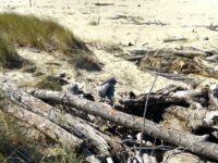
Wood pieces. Wood from flooding dominated the beach. There certainly were many of the above also
New Development
none
Natural Changes
Erosion of vegetated foredune, Evidence of wave overtopping.
Actions & Comments
I can't recall the last time I noted dune erosion on Mile 289. But today was an exceptional day. The swells measured by the off shore buoys were in the 30 foot plus range. The Weather Service had issued a high surf warning with the phrase, "will result in average breaking wave heights around 40 feet." Even in these conditions, the dune erosion was minor and limited to the northern end of the mile.


Report Images
All Mile 289 Reports
Mile 289
Kincheloe Point, South Jetty Tillamook River
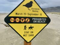
This mile is not surveyed 4 times a year since it became a designated bird nesting area.
ollikainen
Mile 289
Kincheloe Point, South Jetty Tillamook River
There is no trace of nesting bird protection.
ollikainen
Mile 289
Kincheloe Point, South Jetty Tillamook River
September 15 ended the nesting bird restrictions on mile 289.
ollikainen
Mile 289
Kincheloe Point, South Jetty Tillamook River
I saw so many different types of birds along the jetty, I'm no bird expert but I thought I saw pelicans, herons, cormorants, and sea gulls.
EJD
Mile 289
Kincheloe Point, South Jetty Tillamook River
Mile 289 is again restricted due to bird nesting.
ollikainen
Mile 289
Kincheloe Point, South Jetty Tillamook River
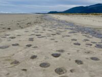
This survey was all about the jelly fish that covered the most recent wrack areas.
ollikainen
Mile 289
Kincheloe Point, South Jetty Tillamook River
This is a partial survey.
ollikainen
Mile 289
Kincheloe Point, South Jetty Tillamook River
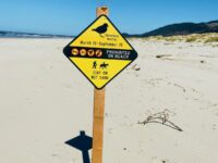
The signage is up again keeping all dogs off Mile 289.
ollikainen

