Community Science
Monitor King Tides to Track Sea Level Rise
Volunteers for the Oregon King Tides Project photograph King Tides to demonstrate current coastal flooding vulnerabilities and anticipate what will become ordinary tide levels as our climate changes. CoastWatch and the Oregon Coastal Management Program provide outreach and training in fall and winter.
The Oregon King Tides Project
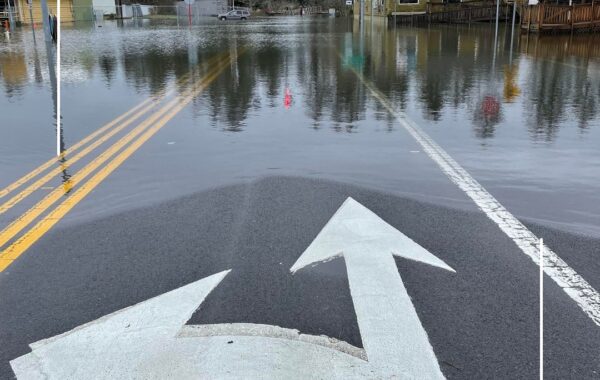
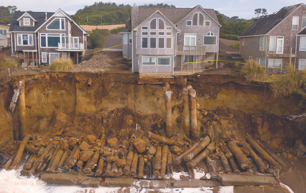
Documenting our coast’s vulnerabilities is a way to plan for our communities’ future, informing residents, visitors, and community leaders of erosion and flooding. Volunteers for the Oregon King Tides Project photograph the reach of the highest tides of winter in coastal towns, roads, beaches, and estuaries to demonstrate current coastal flooding vulnerabilities and to anticipate what will become ordinary tide levels in the future. The highest high tides of the winter are known as King Tides. The term was borrowed from Australia and helped launch a campaign on the American west coast in the mid-2000s to monitor the highest tides of the year to track sea level rise.
Documenting Change
Early every fall, staff at Oregon Coastal Management Program (OCMP), a program of the Oregon Department of Land Conservation and Development, choose a series of dates among the highest of the high predicted winter tides. These dates become a “series,” and volunteers are recruited to photograph their effects from safe distances. Volunteers document flooded infrastructure, buildings, and roads and also the erosion caused by the strong waves that come with King Tides. These photos are published on the Oregon King Tides Project website.
CoastWatch and the OCMP provide outreach in the fall and winter through in-person lectures and virtual talks. These talks review previous year’s photo project trends and sometimes include speakers on coastal resiliency, the science of the tides, and more.
This Season’s King Tides Project Dates:
December 13 – 15, 2023
January 11 – 13, 2024
February 8-10, 2024
To join a community science project, start by adopting a CoastWatch Mile.
Community Science