Mile 94 Report
West of Laurel Lake, Lost Lake
July 7, 2011
Shells, animal casings and small rocks in the driftline.
Report Details
Shells, animal casings and small rocks in the driftline. Practically no trash. No human impact. ATV tracks going north and south on the beach. The mouth of New River is quite narrow (10-20 feet) and is probably shallow but flowing strongly. To the south, the river has meandered twice to the west. At one location, the river now flows over a visible rock fomation, making a gurgling sound. Somewhat farther south, the river meanders again westward, creating a high bluff in the dunes and necessitating a detour to the top of the dunes. This is the second major change seen in New River in over 20 years! The first was when Twomile Creek and New River joined to form a common outlet to the sea. The changes in New River seen today indicates a definite tendency of the river to bend westward again south of where it currently enters the ocean. Old maps show the river entering the ocean to the south of its current outlet. It possibly may form a new more southerly outflow to the ocean in the future.
Conditions
Temperature: 60 F. Cloud Cover: Cloudy. Wind Velocity: Moderate. Wind Direction: NW.
Human Activities
Number of people: 1. Number of dogs: 1. ATV tracks going north and south on the beach.
Driftline Content
Animal casings (e.g., crab, shrimp molt), Shells, Small rocks. Very small pebbles in a few places.
Natural Changes
Erosion of vegetated foredune. See Comments about changes in New River.
Actions & Comments
The mouth of New River is quite narrow (10-20 feet) and is probably shallow but flowing strongly. To the south, the river has meandered twice to the west. At one location, the river now flows over a visible rock fomation, making a gurgling sound. Somewhat farther south, the river meanders again westward, creating a high bluff in the dunes and necessitating a detour to the top of the dunes. This is the second major change seen in New River in over 20 years! The first was when Twomile Creek and New River joined to form a common outlet to the sea. The changes in New River seen today indicates a definite tendency of the river to bend westward again south of where it currently enters the ocean. Old maps show the river entering the ocean to the south of its current outlet. It possibly may form a new more southerly outflow to the ocean in the future.
H Witschi
CoastWatcher
All Mile 94 Reports

Mile 94
West of Laurel Lake, Lost Lake
Accessed mile by rowing down Fourmile Creek and beaching on west side of New River.
John Hull
Mile 94
West of Laurel Lake, Lost Lake
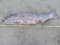
Dead lamb and salmon on the beach.
Volunteer Trainer
Mile 94
West of Laurel Lake, Lost Lake
More people than we have ever seen on a beach walk before, two fishermen in small powered boat on new River, one fisherman walking, and what appeared to be a family of three walking South along the West Bank of the New River.
John Hull
Mile 94
West of Laurel Lake, Lost Lake
Warm day, beach wide and fairly flat, pretty clean with occasional kelp, few jellies, dozens of crab carapaces, a few broken Sand Dollars, feathers, and some other crab parts.
John Hull
Mile 94
West of Laurel Lake, Lost Lake
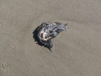
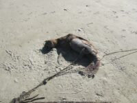
Saw pelican with injured wing walking on beach and a dead baby sealion and three dead birds (just partial carcasses).
John Hull
Mile 94
West of Laurel Lake, Lost Lake
Once again no people nor signs of people.
John Hull
Mile 94
West of Laurel Lake, Lost Lake
Beach sand and wet sand very clean.
John Hull