Mile 157 Report
Oregon Dunes NRA, west of Perkins Lake
March 8, 2008
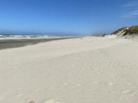
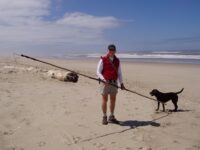
Absolutely beautiful day, shared with my friend and CoastWatch partner Jack Long; wind picked up in early afternoon and got quite chilly, but sunny and lovely and, as usual, not another soul.
Report Details
Absolutely beautiful day, shared with my friend and CoastWatch partner Jack Long; wind picked up in early afternoon and got quite chilly, but sunny and lovely and, as usual, not another soul. We went all the way to the mouth of Tahkenitch Creek and found a protected spot along the creek, behind a big driftwood stump, to eat lunch.
Conditions
Temperature: 50 F. Cloud Cover: Sunny. Wind Velocity: Moderate. Wind Direction: NW. Tide Level: 8.6 feet.
Human Activities
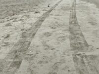
We parked at our secret spot (loophole) and didn't check additional access spots.
Notable Wildlife
Saw a total of perhaps 50 sanderlings feeding.
Beached Birds
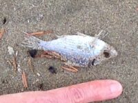
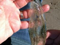
Total dead birds: 3. Two probably shearwaters--from length of wing chord (and look of bill; one was headless) appear to have been short-tailed or sooty shearwaters. One mystery wing--all black feathers, short wing, not typical of swimming or soaring birds, way too small for crow; any ideas?
Driftline Content
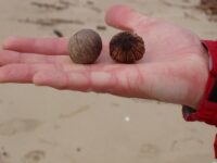
Seaweeds and seagrass, Animal casings (e.g., crab, shrimp molt), Animal casings (e.g., crab, shrimp molt), Shells, Small rocks. Not much; smattering of mole and Dungeness crab, etc.
Natural Changes
Visible retreat of solid bluff. Some foredune erosion; see general comments
Actions & Comments
After all the recent reports of cannons, beeswax and old shipwrecks appearing in the past month on the Oregon coast, we fully expected to see the fishing boat on Mile 157 fully exposed, but it was entirely under sand--no sign of it. In fact, the sand volume on Mile 157 seemed quite high, as it has been for the past couple of years. Notable finds in the driftline: one Earth-type shoe (worn) and one brown (beer-type) bottle with brown cap and "Blackcaps New Zealand" in black lettering; I couldn't find a beer called Blackcaps on the Internet, but there is a team (rugby?) in New Zealand called the Black Caps.Interesting note (to me); we were there at the height of the tide and even had to leap onto the foredune when the highest wave crested. I noted the time: 12:35 p.m. Back home, checked tide table on the Hatfield MSC Web site, and it listed high tide at Agate Beach as 12:35 p.m. So the timing of the tides at Mile 157 seems to correlate very closely with that at Agate Beach.

Report Images
bzenderson
CoastWatcher
All Mile 157 Reports
Mile 157
Oregon Dunes NRA, west of Perkins Lake
It was another beautiful day on Mile 157, which we entered from the upper part of the Oregon Dunes Loop Trail.
GasiorowskiM
Mile 157
Oregon Dunes NRA, west of Perkins Lake
Mile 157 is a beautiful, little-visited stretch of coastline.
GasiorowskiM
Mile 157
Oregon Dunes NRA, west of Perkins Lake
Beautiful New Years Day at the beach, while it was cold and foggy in the valley.
bzenderson
Mile 157
Oregon Dunes NRA, west of Perkins Lake
A rainy day; we had the beach to ourselves.
bzenderson
Mile 157
Oregon Dunes NRA, west of Perkins Lake
Gorgeous day at the beach (crappy and cloudy and cold in Eugene).
bzenderson
Mile 157
Oregon Dunes NRA, west of Perkins Lake
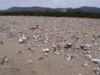
There is a lot of buzz about whether the stuff on the beaches these days is from the tsunami.
bzenderson
Mile 157
Oregon Dunes NRA, west of Perkins Lake
Fair amount of ocean-borne debris, but unlike my last walk here about a month earlier, when the debris was d0ominated by Japanese plastic bottles (tsunami debris?
bzenderson

Mile 157
Oregon Dunes NRA, west of Perkins Lake
Stunning winter day; we were totally overdressed, kept shedding clothes to the brink of immodesty.
bzenderson