All Mile 159 Reports
Mile 159
Oregon Dunes NRA, west of Carter Lake
This is a beautiful, isolated stretch of coastline.
GasiorowskiM

Mile 159
Oregon Dunes NRA, west of Carter Lake
Very quiet pleasant day with beach clear of debris by recent high winds.
JMorris
Mile 159
Oregon Dunes NRA, west of Carter Lake
Calm day between storms, remote mile, requires long hike, not practical to cross Siltcoos river at mouth due to high flow.
JMorris
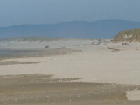
Mile 159
Oregon Dunes NRA, west of Carter Lake
Closest access to this mile is via the Turner Lake Wayside.
Foggy