Mile 305 Report
Oswald West SP, Cape Falcon N
June 3, 2007
This sheet supplements my report about my visits to Mile 305 on June 1, 2, and 3, 2007.
Report Details
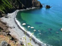
This sheet supplements my report about my visits to Mile 305 on June 1, 2, and 3, 2007. On those dates, I arrived topside about 7:00 AM each morning, descended by my usual route near the boulder garden and hiked as far south as Cove 8 each time. It's really just impossible, or at least very inadvisable, to go past the south wall of Cove 8 (covered in a mass of anemones) unless the tide is ultra-low.On each visit I encountered a dozen seals on the beaches of Coves 6 to 8 and took several pictures. I observed some pups apparently nursing while resting next to their mothers. I took extreme care to stay as far from them as possible, but on June 3, I almost tripped over a seal pup concealed behind a rock!Of the two routes I have used in the past, the trail running across the cliff face to within 50 feet of sea level is too dangerous to use until someone with proper gear and know-how replaces its ropes and anchors. The makeshift zigzag trail marked by some else's old ropes is not much better, but I am able to use my own ropes in that area and can negotiate it fairly easily. (A hardhat, tough gloves, and familiarity with rope and knots is a must.)
Conditions
Cloud Cover: Cloudy. Wind Velocity: Calm/Light. Wind Direction: NW.
Notable Wildlife
12 seals resting/nursing, Cove 6
Dead Fish or Invertebrates
Recently deceased starfish - 10 to 20 mussels - some alone, others in groups
Man-made Modifications
Only natural rearrangement by ocean waves
Natural Changes
Landslides/major boulder falls. Saw a natural one occur on 6-1-07
Actions & Comments
This sheet supplements my report about my visits to Mile 305 on June 1, 2, and 3, 2007. On those dates, I arrived topside about 7:00 AM each morning, descended by my usual route near the boulder garden and hiked as far south as Cove 8 each time. It's really just impossible, or at least very inadvisable, to go past the south wall of Cove 8 (covered in a mass of anemones) unless the tide is ultra-low.Weather over all three days was variable, but mostly low surf, no rain, and pleasant most of the time. On each visit I encountered a dozen seals on the beaches of Coves 6 to 8 and took several pictures. I observed some pups apparently nursing while resting next to their mothers. I took extreme care to stay as far from them as possible, but on June 3, I almost tripped over a seal pup concealed behind a rock!In the coves where debris tends to wash up and remain, I found atypical numbers of dead starfish and mussels - the latter were sometimes individuals, sometimes in clumps. As I hiked through Cove 4, I observed a fairly large natural landslide descend over the debris of previous landslides, and I kept my distance until it had concluded.On each trip, I completed a portion of the litter pickup program I put together for myself. At this writing, there is a giant stack of trash on Black Sand Beach (Cove 1), upon which I placed logs to try to keep it secure above the mean high tide line against wind and sea. This pile includes a full-sized crab trap, two 50-gallon drums (one metal, one plastic), a dozen or so crab pot floats and buoys, a sizable mess of rope (both synthetic and natural), a length of thick metal cable, and a dozen or more heavy-duty nylon sacks filled with all sorts of garbage, including plastic bottles, piece of Styrofoam, and pieces of clothing. In Cove 4, perhaps half a mile to the south, I have secured 16 additional heavy-duty bags of garbage above the mean high tide line in a similar manner. I plan to bring those to Cove 1 during the next set of low tides, which will take time and effort, but I can get it done.Since my return, I have sent e-mails to (among others) the CoastWatch listserve, a Coast Guardsman stationed in Garibaldi, the Oregon Dungeness Crab Commission, one of the state park employees whose jurisdiction includes Oswald West State Park, the Oregon State Marine Board, and SOLV. I have received favorable responses and advice, and it appears we will be able to remove the trash before the high tides of winter redistribute it along the coastline. I've put too much work into this project not to see it completed!Of the two routes I have used in the past, the trail running across the cliff face to within 50 feet of sea level is too dangerous to use until someone with proper gear and know-how replaces its ropes and anchors. The makeshift zigzag trail marked by some else's old ropes is not much better, but I am able to use my own ropes in that area and can negotiate it fairly easily. (A hardhat, tough gloves, and familiarity with rope and knots is a must.)Before the last daylight low tides of 2007 have passed, I intend to return to Coves 9 and 10, now that I know and remember how to negotiate them. At some point, I am sure it'll be impossible to go any further south, but the astounding rock formations and the simple possibility of discovering more amazing sights is just too strong a lure. I promise to take care and do my best to avoid becoming a meal for the local residents of the shore and sea!SUPPLEMENT:In connection with this trip to Mile 305, I found a new, better, and safer way to access Black Sand Beach. As noted in previous reports, there are two primary routes: one along the face of the cliff on the old quarry trail, and one which descends down to a boulder garden a bit further to the north along a cliff face.The quarry trail and its ropes have become unstable, and one of the ropes broke in my hand while I was testing it! Without the placement of more and better ropes and pitons by experts, this route is extremely dangerous and should be avoided.The trail down the cliff face to the boulder garden is a bit safer, but not by much. The ropes there are worn and can be used only at your own risk. I bring and use my own climbing ropes. But on reaching the first of the large rocks, if one turns left (south) and stays fairly close to the cliffside, it is possible to get over the boulders and onto the beach without getting too near the sea. I still recommend accessing this route only at low tides and in the best of weather, using a hardhat and other climbing gear, and it is by no means risk-free. But it beats playing hopscotch on the rocks near the ocean. They are covered with slippery marine life!On this visit, the tide did not permit me to leave Black Sand Beach in either direction, so I spent about an hour picking up and securing litter in bags. I managed to break the rusted, buried crab pot free, and if I can find a way of hoisting it up the cliff, I will get it off the beach. I left the bagged litter up above the high tide line for the time being.Due to some upcoming low tides, I think I will be able to get into the far coves again in 2007. I plan to take some large bags, collect litter, and move it northward as far as I can get it, and then perhaps make a special trip solely for the purpose of getting the trash up and out of the place. This might be a two-person job. If I can secure a rope of sufficient length, the best way to get the stuff up would be for one person to tie it on down below, a bag at a time, and have a second person on top to hoist it up, who would just need to be careful not to fall off the edge! It is a long fall, and the sudden stop at the end would be unpleasant.The soil and rocks are very irregular on the cliff face, and I left a fair amount of myself out there on this trip. I'll be wearing shin, knee, and elbow padding next time. But the discovery of this easier and (relatively) safer route means that I can get to these areas more often and stay longer on each visit, and in turn, that means I have a better shot at getting the trash out of there.
skyhar8000
CoastWatcher
All Mile 305 Reports
Mile 305
Oswald West SP, Cape Falcon N
In 50 plus years of visiting this small cove, this is the only time I've ever seen it this calm.
Frankie

Mile 305
Oswald West SP, Cape Falcon N
First and probably only time I will see my mile in 2015.
skyhar8000
Mile 305
Oswald West SP, Cape Falcon N
A great day for a hike during one of the year's lowest tides.
skyhar8000
Mile 305
Oswald West SP, Cape Falcon N
Great hike to very end of possible area to walk in due to extremely low tide.
skyhar8000
Mile 305
Oswald West SP, Cape Falcon N
Four of us arrived 0600 hours and left about 0900 hours.
skyhar8000