Mile 305 Report
Oswald West SP, Cape Falcon N
April 20, 2007
Beyond the turnaround, a trail leads south past the Oswald West State Park boundary line which is indicated by two signs, one fastened to a tree, the other on a metal ground stake.
Report Details
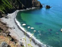
Beyond the turnaround, a trail leads south past the Oswald West State Park boundary line which is indicated by two signs, one fastened to a tree, the other on a metal ground stake. A short distance beyond the signs, one has the choice of continuing south or turning west. The former choice leads to an old eroded trail that can be negotiated to the beach only by using some old ropes and stakes left by other hikers. The latter choice leads to a cliff trail that features ropes but which is less hazardous than the eroded trail, and here I descend.[...See Comments section for 3 pages of fascinating details...]I call Cove 5 Seal Harbor. Last year, I found several pups in it, with the adults out in the surf, waiting for the pups to rest. Today I have found several DOZEN seals in it of all sizes, and I took as many pictures as possible, while they slid slowly across the rocks and into the ocean. I think the seals use this cove because the rocks on the beach are smooth and round. There are dozens of "seal trails" where it is evident they have maneuvered up to the cliff base itself. This cove is not very large.
Conditions
Cloud Cover: Sunny. Wind Velocity: Calm/Light. Wind Direction: W.
Human Activities
It is inevitable that I come upon the occasional group of seals. I stay as far away as possible, photograph them at a distance, and give them as much room as I can, and the option to stay onshore or leave.
Notable Wildlife
Today I have found several DOZEN seals in it of all sizes
Actions & Comments
This sheet contains supplemental information for my April 20, 2007 visit to my area. It will probably provide more information than most CoastWatch reports, but tide and weather prohibit regular visits to the area, so I will try to gather and submit as much detail as possible in each report.On the above date, I parked at the end of Elk Flat Road about 8:00 AM and hiked south past the swinging wooden gate and three houses above the roadway. The road ends in a large turnaround area, where a giant tree has lost its crown in a windstorm. Its wood was rotted, and the broken treetop rests in two large piles near the tree itself.Beyond the turnaround, a trail leads south past the Oswald West State Park boundary line which is indicated by two signs, one fastened to a tree, the other on a metal ground stake. A short distance beyond the signs, one has the choice of continuing south or turning west. The former choice leads to an old eroded trail that can be negotiated to the beach only by using some old ropes and stakes left by other hikers. The latter choice leads to a cliff trail that features ropes but which is less hazardous than the eroded trail, and here I descend.I brought my own rope, and where the old ropes leave off, I affix my own rope and use it to get down as far as a boulder field. The rocks are difficult to clamber over, and the sea is seldom far away. On my return trip, I was completely drenched by a large wave just as I began to ascend. This journey is not for the timid.From the boulder field, it is a short (but treacherous) trip to the north end of a large cove I have heard other people call Black Rock Beach or Black Sand Beach. An aerial view can be found at www.mapquest.com -- simply enter "Arch Cape" as the city and "Oregon" as the state, then scroll south and magnify to the third closest setting (the website refuses to get any more detailed than that). From the beach below Falcon Cove Road, simply look south around the first headland, and the next dark coastal area is Black Rock/Sand Beach.I have numbered the coves beginning with area as Cove 1. It is perhaps 200 yards long. A rusted metal barrel rests near the foot of the ropes leading down from the eroded trail. There are some Styrofoam floats, pieces of Styrofoam and some plastics bottles about.At the south end of Cove 1 is a broken outjutting of rock I call Broken Head. It is hard to negotiate at low tide and impossible at all other times. Slipping around Broken Head gets you into Cove 2. The rocks underfoot are no longer black and round - they are a mixture of black rounds and broken, irregular brown rock from the cliff faces, which are really rather spectacular, but very fractured, so I always wear a hardhat. Cove 2 has some old Styrofoam floats and plastic bottles, and also a large white plastic drum, empty, 50-55 gallons (has both a top and bottom and Made In USA on one end). No idea of its original contents. this is also the first cove with lots of live birds, various species, which send up an alarm cry when they see me. Debris catches in this area because there is a fairly wide gap between the cliff faces and the mean high tide line. I hope to come back and gather the debris and dispose of it, if I can figure out how to carry it away with me.Passing into Cove 3 is easy - there are a couple of "perpetual puddles" of ocean water, and a small hole in the rocks, easily negotiated. Having stepped through the hole, you can turn around and take a picture of Tillamook Head, with some other ocean-bound rocks in the foreground; it makes a great photo. There is a little debris, but not much to see, probably because this cove is shallow and susceptible to being scrubbed out by a wind-driven high tide. this cove is generally small and unremarkable.Passage into Cove 4 is not difficult, but it is a bit deceptive. There is an inviting pathway close to the cliffs, but it is too steep once you have ascended it and are looking down into that cove. It is better to move away from the cliffs and select the passage closer to the sea that is easily negotiated. You can also walk even more westward and skirt the entire rock formation if you wish, but I recommend the midway passage just for the fun of it.Cove 4 is fairly large and its floor is covered with soft black sand - so soft that if you set foot too near a recess full of water, you will slide right into it. In the midst of the cove is a sea rock I call Everest due to its shape. There is also a large vertical stick, perhaps set up by nature, perhaps by humans. This cove is very deep and has accumulated a lot of debris, mostly Styrofoam and plastic. If you got stuck due to incoming tides, this cove would offer the best chance of survivial, as it appears the ocean seldom reaches the cliffs.Moving toward Cove 5, you pass Two Towers Rock, which resembles one of the towers in the second "Lord of the Rings" movie. As you pass this rock, for the first time you can see, at the base of the cliffs, where the water has slowly worn rounded holes in the cliff bases. There is an optical illusion that makes it appear that the ocean will collapse upon you at any moment. The passage into the next cove is marked by some slick rocks I call the Stepping Stones, and they are accessible only at very low tide levels; otherwise, you are forced to wade around or over them.I call Cove 5 Seal Harbor. Last year, I found several pups in it, with the adults out in the surf, waiting for the pups to rest. Today I have found several DOZEN seals in it of all sizes, and I took as many pictures as possible, while they slid slowly across the rocks and into the ocean. I think the seals use this cove because the rocks on the beach are smooth and round. There are dozens of "seal trails" where it is evident they have maneuvered up to the cliff base itself. This cove is not very large.Accessing Cove 6 is not difficult; you walk past a rock I have dubbed Bishop's Hat, as it looks like a miter worn by the clergy. There is a wonderful rock perhaps two feet across with numerous large holes I have named the Bowling Ball. Here there are more rounded areas, where the ocean has eroded the cliff base more severely. There are also rocks with brown markings that are exceptionally beautiful, scattered over the floor of the cove, and I have pictures of many of them.In this area, the ocean has also worn away enough of the cliff that there are a few column formations that are free standing; that is, you can pass behind them. There is a sea rock I named The Matterhorn for its shape. The south cove wall is covered with sea anemones. This warns hikers that the ocean frequently covers the area - don't stay here too long!!At this point, I have run out of time and must beat a retreat before the ocean traps me. I have seen two new phenomena. One is an orange buoy forced far back into a crack in the rocks, which I call The Grotto, as it looks like some sort of shrine. The other is called the Crossbar, which is a log rammed into a cliff crack and is several feet off the ground but is also parallel to it. There is another cave beyond, but I don't have time to explore it, and I am concerned about its floor. It is water-filled and could be waded, but if the sand in it is too soft, one may find it difficult to get out, once one has gotten halfway through, and to get stuck would undoubtably be fatal. This may require two people and a rope for safety!From this area, you can see a small hole in the underside of The Matterhorn, and I will count the standing columns as I leave. There is one next to the Grotto, then a small one that looks like a lady's boot. The next one, you could walk around it freely, and there is a small drip of water behind it that appears to descend through solid rock. Then there is one you could crawl through, and then a last one near The Matterhorn you can walk all the way around. I have photographed a round rock with large holes -- the Swiss Cheese.My notes are not as accurate with respect to the last coves visited because time has grown short, and the return trip will not be as much fun -- also, I simply start to run out of energy but must negotiate all the headlands before the tide comes in too far.When I got back to the ascension point, I was amazed to see how far the tide had come in already, and while trying to scramble up the ropes, I was thoroughly doused by a wave that broke on the rock just west of the one I was standing on. It soaked my clothing, and it killed my portable tape recording machine, but my camera survived the drenching. I also got past my purple rope, and had just coiled it for carrying when I dropped it and had to descend to retrieve it. No fun! This is as close as I have come to not returning at all.Just as I got back to the car, I encountered several students and a teacher from the local school (Fire Mountain) on an Earth Day hike, so I shared the pictures in my camera with them and gave an impromptu talk about my day's hike. I left from home at 10:30 AM.Remaining days in 2007 when these areas will be accessible via foot: May 15-21; June 2-5; June 13-18; June 30-July 3; July 12-16; July 29-31. Again, this is a dangerous area. It should not be hiked at night; when wind-driven waves prevent the tide from becoming as low as listed in the tables; or in the rain, or when rain appears possible. The cliffs are steep and unstable, and many of the headland areas are slick and unpredictable. In many areas, an injury would mean certain death. I do not traverse this area without my survival gear, a hardhat, and a reliable watch. Several times I have abandoned a hike (sometimes not even leaving my car) because weather or tide conditions weren't just right.This information is for the convenience of the reader, and the author assumes no liability for its accuracy, or for injury, death, and or loss or property to/of any person who makes the decision to survey or travel in, over, through, to, or from this area, based on the statements made herein. If you go, use common sense, and take appropriate precautions. It is a beautiful area, seldom seen up close by humans, but to maximize your chances of living to hike another day, extreme caution is essential.
skyhar8000
CoastWatcher
All Mile 305 Reports
Mile 305
Oswald West SP, Cape Falcon N
In 50 plus years of visiting this small cove, this is the only time I've ever seen it this calm.
Frankie

Mile 305
Oswald West SP, Cape Falcon N
First and probably only time I will see my mile in 2015.
skyhar8000
Mile 305
Oswald West SP, Cape Falcon N
A great day for a hike during one of the year's lowest tides.
skyhar8000
Mile 305
Oswald West SP, Cape Falcon N
Great hike to very end of possible area to walk in due to extremely low tide.
skyhar8000
Mile 305
Oswald West SP, Cape Falcon N
Four of us arrived 0600 hours and left about 0900 hours.
skyhar8000