Mile 236 Report
Gleneden Beach, State Wayside
November 23, 2009
Unusual amount of driftwood for this beach, due to storms and wind directions.
Report Details
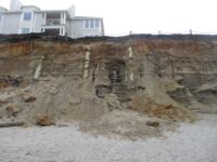
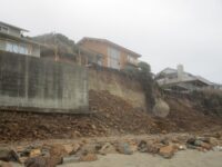
Unusual amount of driftwood for this beach, due to storms and wind directions. Only notable difference to shoreline is erosion of fill material at the beach rescue access south of Laurel Street. Riprap was replaced three years ago when houses teetered on the edge, and access was rebuilt with large boulders. Boulders now must be traversed to move from land to shore, making it nearly impassable. Will check on this again in January.
Conditions
Temperature: 40 F. Cloud Cover: Rain. Wind Velocity: Moderate. Wind Direction: SW. Tide Level: 6.8 feet.
Human Activities
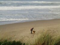
Number of people: 9. Number of dogs: 4. Walking or running: 6. not enough beach to allow for much activity, as tides were pushing to the bulkheads; even low tides threatened beachcombers; at the foot of Wallace Street sat a collection of huge machinery. Sign saying “beach repair equipment” – a very large backhoe, a medium sized backhoe, and a road grader with wide bucket. A pile of large gravel at the access. Could not tell what they were doing. No humans.
Concerns
Driftwood removal, Litter
Apparent violations: : A couple was loading a few logs into their pickup at the Laurel Street access; found a recently consumed can of spaghetti, with plastic fork and a pink plastic bowl discarded at foot of Laurel access signposts (think debris unrelated to driftwooders)s.Vehicles
Cars/trucks parking: 2.
Notable Wildlife
1 dead crow 1 dead egret (?) three pieces of a dark brown-feathered bird. The wing from elbow/wrist to tip was 12” – whole length nearly 2 feet. Pronounced yellow hooked beak on one of the pieces. I think these are pieces of two whole birds.
Beached Birds
Total dead birds: 5.
Driftline Content
Seaweeds and seagrass, Animal casings (e.g., crab, shrimp molt), Land-based debris (picnics, etc.), Marine debris (plastic, styrofoam, etc. washing in from the sea), Shells, Small rocks, Styrofoam, Wood pieces.
Natural Changes
Landslides/major boulder falls.
Actions & Comments
Due to erosion of fill, boulders have been exposed at rescue access south of Laurel, making the access nearly unpassable. I will check on this in January and contact authorities if it has not been amended. This is the area where three houses were threatened by eroded cliffs during November storms 3 years ago.
Streets
CoastWatcher
All Mile 236 Reports

Mile 236
Gleneden Beach, State Wayside
After a spate of sunny weather, we finally have rain, or at least drizzle.
Streets
Mile 236
Gleneden Beach, State Wayside
A relatively dry afternoon; maybe three people besides me.
Streets
Mile 236
Gleneden Beach, State Wayside
As I don't live here, there's a lot that I miss.
Streets
Mile 236
Gleneden Beach, State Wayside
It has been a while since I've been able to cover my mile.
Streets
Mile 236
Gleneden Beach, State Wayside
Storm damage for this mile seems mostly at Laurel/Sijota; Morris Excavation has built a roadbed parallel to the bluff for equipment access; some erosion at World Mark, north of state park.
Streets
Mile 236
Gleneden Beach, State Wayside
Remarkably little debris - anticipating a different story after the King tides!
Streets
Mile 236
Gleneden Beach, State Wayside
Gorgeous afternoon, bracing wind, an unobscured sun as it nears the horizon
Streets